


IN PHOTOS: The Magical Mystery Tour of the Station Road Diversion Route in Ilminster

WELCOME aboard Ilminster Press Tours as we take you on a pictorial journey on the diversion route around the 550-metre closure of Station Road – one of the gateways into the town.
Work started today (Monday, February 22, 2016) on drainage works in Station Road which will see it closed to motorists for up to five weeks.
Although most local people will realise that there are far easier ways to get around the closure – the official diversion route laid out by Somerset County Council’s highways department is an amazing 24-miles long!
So sit back and enjoy the ride as we show you what you could enjoy if you decide – over the next five weeks – to go out for the afternoon for a “ride in the car" and take the Station Road diversion route.
PHOTO – TOP: The roadworks at Station Road in Ilminster from the town side of the closure.


PHOTOS – ABOVE: The “road closed” signs at the roundabout near to the Stonemasons pub car park in Ilminster.

PHOTO 1 ABOVE – ONE-AND-A-HALF MILES: At the start of our journey from the car park at the Stonemasons pub we travel through Ilminster up Station Road and past the Shrubbery Hotel before turning left into New Road and the B3168. We drive up the hill and then leave the town before – on your left – you will see Ilminster Cemetery.

PHOTO 2 ABOVE – THREE MILES: We arrive at Puckington with a population of just over 100 people. INTERESTING FACT: The name of the village means the “settlement of Puca’s people.”

PHOTO 3 ABOVE – FIVE MILES: We arrive at the village of Westport. INTERESTING FACT: Westport lies on the disused Westport Canal.


PHOTOS 4 and 5 ABOVE – SIX MILES: We arrive at Hambridge where we took a short stop to look at the village church. INTERESTING FACT: Hambridge is most notable as the place at which Cecil Sharp was inspired by the Rev Charles Marson, vicar of Hambridge, to begin collecting folk songs.

PHOTO 6 ABOVE – EIGHT MILES: We arrive at Curry Rivel – twinned with Chevilly in France – and has a population of around 2,500 people. INTERESTING FACT: The name Curry Rivel comes from the Celtic word crwy, meaning boundary, and Rivel from its 12th century landlord Sir Richard Revel.

PHOTO 7 – NINE MILES: We turn left onto the A378 at the War Memorial in the centre of Curry Rivel.

PHOTO 8 – TWELVE MILES: We journey onto Fivehead with a population of just over 600. We apologise for the poor photograph, but our tour guide took it from the safety of his parked car rather than get out and dice with danger of other passing motorists. INTERESTING FACT: The name of the village comes from a Domesday manor which measured five hides (an old English unit of land measurement).

PHOTO 9 – FOURTEEN MILES: We arrive at the village of Wrantage. INTERESTING FACT: An old aqueduct from the Chard Canal now supports farm buildings at Wrantage.


PHOTOS 10 and 11 ABOVE – SEVENTEEN MILES: We arrive at the crossroads of Thornfalcon and see the signpost for Ilminster onto the A358. INTERESTING FACT: The name of Thornfalcon comes from Thorn, and the personal name Fagun (now Falcon) which was the Norman surname of Sir Gilbert of Thorn, whose family were lords of the manor until the 14th century.


PHOTO 12 AND 13 – TWENTY-FOUR MILES: We arrive back in Ilminster and the other end of the road closure in Station Road just off the Southfields Roundabout. INTERESTING FACT: In 1645 during the English Civil War, Ilminster was the scene of a skirmish between parliamentary troops under Edward Massie and Royalist forces under Lord Goring who fought for control of the bridges prior to the Battle of Langport.
And that concludes our Magical Mystery Tour of the Station Road Diversion Route – all 24 miles of it. Remember – if you want to enjoy the same drive…..you have five weeks.

PHOTO - ABOVE: A map of the diversion route (in blue) to get around the 550-metres of closure in Station Road (in red).
Tags:
News.
Recent Posts
 ILMINSTER NEWS: Coffee morning raises an amazing amount of money!
 ILMINSTER NEWS: Actor James Purefoy to switch-on Ilminster’s Christmas lights
 Coronation of King Charles III
 RIP Queen Elizabeth II – who served the UK and Commonwealth with such distinction
 ILMINSTER NEWS: We must all keep the community spirit shining bright in Ilminster
 ILMINSTER NEWS: More 20mph speed limit signs are needed in town centre say residents
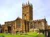 ILMINSTER NEWS: Organ concert at The Minster will be one not to be missed
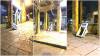 ILMINSTER NEWS: Cash point explosion rocks Ilminster town centre
 ILMINSTER NEWS: Swanmead headteacher devastated at council’s decision
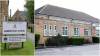 ILMINSTER NEWS: Council makes “significant milestone” for education future
 ILMINSTER NEWS: Swanmead governors are shocked and angry over planned education changes
 COMPETITION: Sophy’s great New Year giveaway competition
 SOUTH SOMERSET NEWS: Julie remembers the Munich tragedy of the Busby Babes
 ILMINSTER NEWS: Have YOUR say NOW on controversial school changes
 ILMINSTER NEWS: Council ploughing ahead with controversial school changes